Have any questions?
get in touchTel : +86-13641430137
Whatsapp : +86-13641430137
Skype : ourskeeper
E-mail : info@duuhnn.com
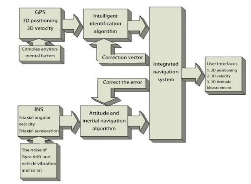
The GPS Inertial Navigation Sensor is used for output harsh even alarm via connecting GPS tracker or MDVR.
Brand:
DUUHNNItem NO.:
DH-TS07Order(MOQ):
1pcsPayment:
TT, Paypal,Western Union,MoneyGram,AlipayPrice:
Warranty:
2YearsDelivery Time:
3-8 working days for sampleMain Features
1. Harsh Event Alarm with Accelerometer Data Output via RS232 Interface
Automatics Calibration for 6-axis G-Sensor, no special request for installation direction or vehicles.
Harsh Even Alarm:
Harsh Braking,
Harsh Acceleration
Harsh Cornering
Collision Alarm
Harsh Lane Departure Alarm
High Accuracy Vehicle Speed, Odometer with Ublox 8030 & Bosch 6-axis Inertia Navigation Technology
Programmable Threshold for G value of Alarms.(suggest default setting)
2. Interface
RS232 Output(default 115200 baud rates, 8-N-1):
Standard: NMEA0183 , like GNGGA, GNRMC, GNGSA, etc.
Private: Debug , GPATT with harsh event alarm data.
SMA connector for 1meter external GPS+Glonass Antenna
3. Size and Power Supply
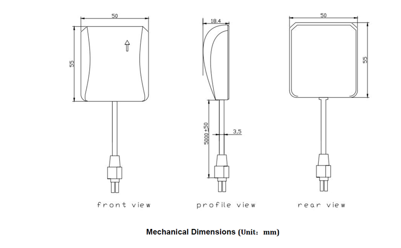
Mini Size: 4.5cm(L)x1.9cm(W), 100cm extended cable
PowerSupply: DC5V
4. GPS Features
Build on high performance,low-power GNSS U-blox UBX-M8030-KT chipset
Support satellite systems: GPS, Glonass Galileo, Beidou
Ultra high track sensitivity: -167dBm
Baud rate:115200
Protocol compliant NMEA-0183, UBX, RTCM2.3
The built-in six-axis acceleration sensor can be used to define various gravity algorithms
Automatically inertial navigation positioning without GNSS signal
Built-in high gain LNA to improve receiving sensitivity
Automatically save GNSS log information
Operating voltage: 3.0V~5.5V
Power consumption: 140mA~150mA
Operating temperature range: -40to85℃
Patch Antenna Size:35x35x4mm
Small form factor: 55x50x18.4mm
Communication type: RS232
Wire interface type: Molex 4PIN , L=500CM
Waterproofing grade: IP41
RoHS compliant (Lead-free)
Technical Specifications
Input voltage: 5V DC Power consumption: Passive - 240mW Active (with antenna) - 480mW Maximum current drain< 25mA Accuracy Horizontal: < 5m (50%), < 8 (90%) Altitude: < 10m (50%), < 16 m (90%) Velocity: < 0.06m/sec = 0.22km/h | Acquisitions After loss of lock: < 2s (90%) First time power applied: < 38s (50%), < 42s (90%) Temporary loss of power: < 10s (50%), < 13s (90%) Operational limits Altitude: 18000m Speed: Max300KM/H |

Debug Protocol
$DEBUG | Head |
1 | ANG_DGet_Flag |
1 | Fix_Kind_Flag |
2 | Inetial Nav Status |
0.023 | Fix_Roll_Flag |
-3.76 | Fix_Pitchl_Flag |
2 | Harsh Alarm Status |
2 | Evant Flag |
-32 | UBI_A |
0 | UBI_B |
-32 | ACC_X_DATA |
-5 | ACC_Y_DATA |
0 | ACC_Z_DATA |
1 | Pitch_Angle |
-1 | _Roll_angle |
0 | Yaw_Angle |
4 | Car_Speed |
4 | INS_FLAG |
444 | Serial_Number |
1 | UBI_Valid |
-19 | Coll_T_DATA |
0 | COLL_T_Heading |
74 | Cheksum |
Working Diagram

Application
GPS Tracker, MDVR, Telematics Devices, Transport Fleet, Fleet Management, IOT Sensor, Vehicle M2M Platform
Related Tags :